






































Coordinates are latitude, longitude in decimal degrees (WGS 84).

  1. 66.84203871663892, 13.466422796249379
  2. 66.82196855625862, 13.342540667064714
  3. 66.834618597626, 13.400138871943161
  4. 66.82292909488751, 13.408750759164384
  5. 66.84212417868741, 13.466849178023427
  6. 66.82336085186984, 13.409240366188588
  7. 66.81885957710519, 13.41523377719108
  8. 66.84543193978449, 13.43374064715268
  9. 66.82197556271967, 13.41426900536669
  10. 66.83213120269993, 13.402805924415793
  11. 66.8237327720224, 13.348837703514791
  12. 66.81686372598224, 13.408739449655256
  13. 66.82035450965996, 13.337205561673207
  14. 66.82334852577858, 13.399817949091947
  15. 66.86842887616216, 13.705041552436548
  16. 66.86829323801891, 13.704666254012968
  17. 66.87186309896069, 13.707670508178849
  18. 66.79554081603636, 13.441868220849939
  19. 66.69517715616958, 13.766727447509767
  20. 66.69835888994209, 13.650712991391982
  21. 66.69722555196292, 13.691402503647936
  22. 66.92060958000577, 13.622497606661387
  23. 66.92195163091468, 13.623225536839922
  24. 66.69928483074024, 13.71148467063904
  25. 66.70306499675577, 13.733612895011904
  26. 66.69416749104799, 13.829732537269594
  27. 66.7100016791059, 13.709027767181398
  28. 66.70727897879685, 13.721001148223879
  29. 66.70505322785425, 13.727545738220217
  30. 66.70071145783837, 13.757500648498537
  31. 66.940404, 13.572814
  32. 66.9355638762474, 13.540446958370929
  33. 66.9203206108779, 13.622241438128002
  34. 66.80245486003179, 13.188067656104945
  35. 66.80104542157818, 13.224647055206477
  36. 66.80386095457119, 13.21351016966922
  37. 66.7892180091329, 13.124924504383895
  38. 66.79970207553208, 13.22310697599356
  39. 66.79743548653676, 13.215399720417128
  40. 66.934346, 13.522963
  41. 66.82255511468135, 13.407071051434277
  42. 66.82439472581102, 13.406276136936931
  43. 66.82347156809355, 13.406767081261046
  44. 66.933168, 13.518097
  45. 66.81562032501284, 13.937263516271141
  46. 66.81240025010652, 13.965651129342485
  47. 66.90956907870488, 13.63377571105957
  48. 66.81718526943135, 13.941054431292477
  49. 66.81145519092958, 13.980749649519199
  50. 66.81394025437443, 13.966155938595882
  51. 66.81086233910341, 13.88632297735874
  52. 66.81106413260048, 13.883712963299422
  53. 66.82267133224768, 13.40682216833223
  54. 66.77774619217725, 13.450493854444563
  55. 66.79419376100297, 14.008305851734422
  56. 66.79702658936306, 14.000280846371828
  57. 66.79693373484452, 14.00096068670254
  58. 66.82333585821746, 13.399893283843983
  59. 66.8186856873437, 13.414783217978341
  60. 66.82897351447136, 13.415153858647377
  • © Helge Seim

The new center in Meløy

From olden times, Meløy and Rødøy had been 2 parts of the same unit, but over the years they had gradually drifted apart. There were several reasons for this, but it was primarily about distance. In 1884, Meløy officially split from Rodøy. The choice of where the center should be was easy. It had to be the place that had been the center of the parish for hundreds of years. It had to be Meløya. Time passed and after the Second World War the old buildings on Meløya were no longer good enough. Again, the administration was to be moved, but agreeing on where it should be would prove to be a challenge.

Time passed and after the Second World War the old buildings on Meløya were no longer good enough. Again, the administration was to be moved, but agreeing on where it should be would prove a challenge.
 

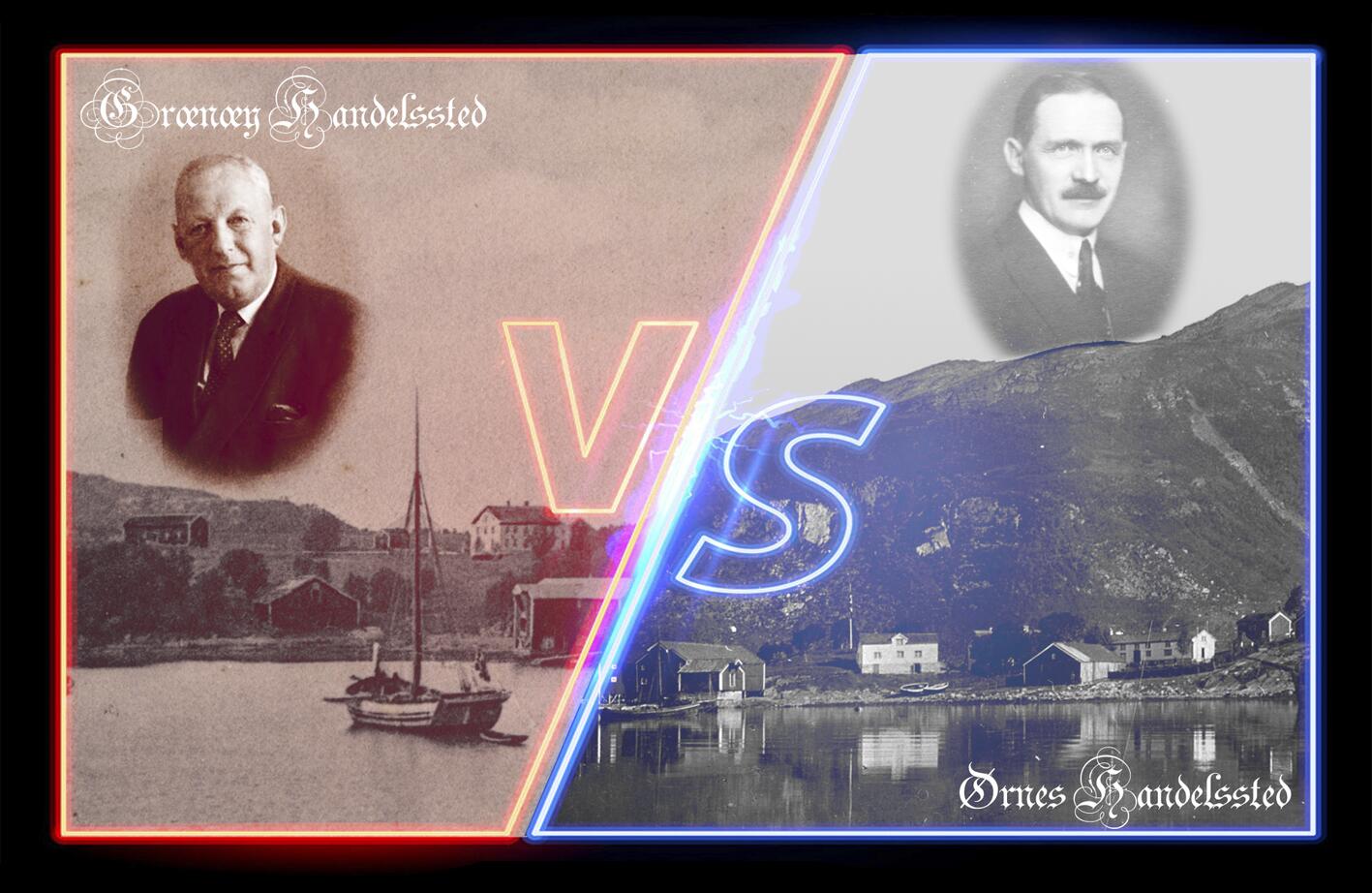
In the early 1950s, there were relatively heated discussions about the relocation of administration from Meløya. The dispute was between Vall in South and Ørnes in the north. The owner of Grønnøy, Fredrik Kristian Meyer, had inherited more than just the name from his father. He was also very committed and was willing to go to great lengths for the administration to be put in his district. It is said that he was willing to move both the steamboat quay and expedition to the other side of the bay if necessary. Sigurd was no worse. He had begun showing his age, but his heart still burned for his village. He had already secured both the old people's home and the dairy and perhaps this was finishing touch of his career
 
One might wonder why the choice was between these 2 places. They are both conveniently located in relation to shipping, but far from perfect. There are probably other places that geographically would have made more sense. The fact that both places had a trading post was probably decisive here. Both Grønøy and Ørnes had a strong leader who was keen to protect his district. And the people were used to following them.
 
The trading posts heyday was indeed long since past in the 1950s. In Meløy, these were the only who still remained and they wore but shadows of their former greatness. Nevertheless, they had great influence and large areas of land. As the administration constantly had new needs for various services, Grønøy and Ørnes had made land available. Both places also had regular public transport routes.
Why the choice ultimately fell on Ørnes is hard to say, but much of the reason probably lies in port conditions and the accessibility to the industrial site of Glomfjord.
 
I think this was probably an example of a tug-of-war between old elites. But even if Fredrik Meyer was determent , social development had transformed Grønøy from the center to the outskirts. The road network was undergoing extensive development and was well on its way to taking over as the main thoroughfare.

Subject text: Helge Seim

Screenplay: Helge Seim og Jan Ivar Bårtvedt

Voice:  Miriam Sollie Iversen

Editing: Helge seim


Musikk og Lydeffekter: freesound.org


Source:

  • Swensen P. , Torsvik U. og Schulz H.(1984) Jubileumsskrift Meløy kommune 1884 - 1984