





































Coordinates are latitude, longitude in decimal degrees (WGS 84).

  1. 66.84203871663892, 13.466422796249379
  2. 66.82196855625862, 13.342540667064714
  3. 66.834618597626, 13.400138871943161
  4. 66.82292909488751, 13.408750759164384
  5. 66.84212417868741, 13.466849178023427
  6. 66.82336085186984, 13.409240366188588
  7. 66.81885957710519, 13.41523377719108
  8. 66.84543193978449, 13.43374064715268
  9. 66.82197556271967, 13.41426900536669
  10. 66.83213120269993, 13.402805924415793
  11. 66.8237327720224, 13.348837703514791
  12. 66.81686372598224, 13.408739449655256
  13. 66.82035450965996, 13.337205561673207
  14. 66.82334852577858, 13.399817949091947
  15. 66.86842887616216, 13.705041552436548
  16. 66.86829323801891, 13.704666254012968
  17. 66.87186309896069, 13.707670508178849
  18. 66.79554081603636, 13.441868220849939
  19. 66.69517715616958, 13.766727447509767
  20. 66.69835888994209, 13.650712991391982
  21. 66.69722555196292, 13.691402503647936
  22. 66.92060958000577, 13.622497606661387
  23. 66.92195163091468, 13.623225536839922
  24. 66.69928483074024, 13.71148467063904
  25. 66.70306499675577, 13.733612895011904
  26. 66.69416749104799, 13.829732537269594
  27. 66.7100016791059, 13.709027767181398
  28. 66.70727897879685, 13.721001148223879
  29. 66.70505322785425, 13.727545738220217
  30. 66.70071145783837, 13.757500648498537
  31. 66.940404, 13.572814
  32. 66.9355638762474, 13.540446958370929
  33. 66.9203206108779, 13.622241438128002
  34. 66.80245486003179, 13.188067656104945
  35. 66.80104542157818, 13.224647055206477
  36. 66.80386095457119, 13.21351016966922
  37. 66.7892180091329, 13.124924504383895
  38. 66.79970207553208, 13.22310697599356
  39. 66.79743548653676, 13.215399720417128
  40. 66.934346, 13.522963
  41. 66.82255511468135, 13.407071051434277
  42. 66.82439472581102, 13.406276136936931
  43. 66.82347156809355, 13.406767081261046
  44. 66.933168, 13.518097
  45. 66.81562032501284, 13.937263516271141
  46. 66.81240025010652, 13.965651129342485
  47. 66.90956907870488, 13.63377571105957
  48. 66.81718526943135, 13.941054431292477
  49. 66.81145519092958, 13.980749649519199
  50. 66.81394025437443, 13.966155938595882
  51. 66.81086233910341, 13.88632297735874
  52. 66.81106413260048, 13.883712963299422
  53. 66.82267133224768, 13.40682216833223
  54. 66.77774619217725, 13.450493854444563
  55. 66.79419376100297, 14.008305851734422
  56. 66.79702658936306, 14.000280846371828
  57. 66.79693373484452, 14.00096068670254
  58. 66.82333585821746, 13.399893283843983
  59. 66.8186856873437, 13.414783217978341
  60. 66.82897351447136, 13.415153858647377
  • Svartisen National Park

    © Erik Bolstad Store norske leksikon

Svartisen National Park

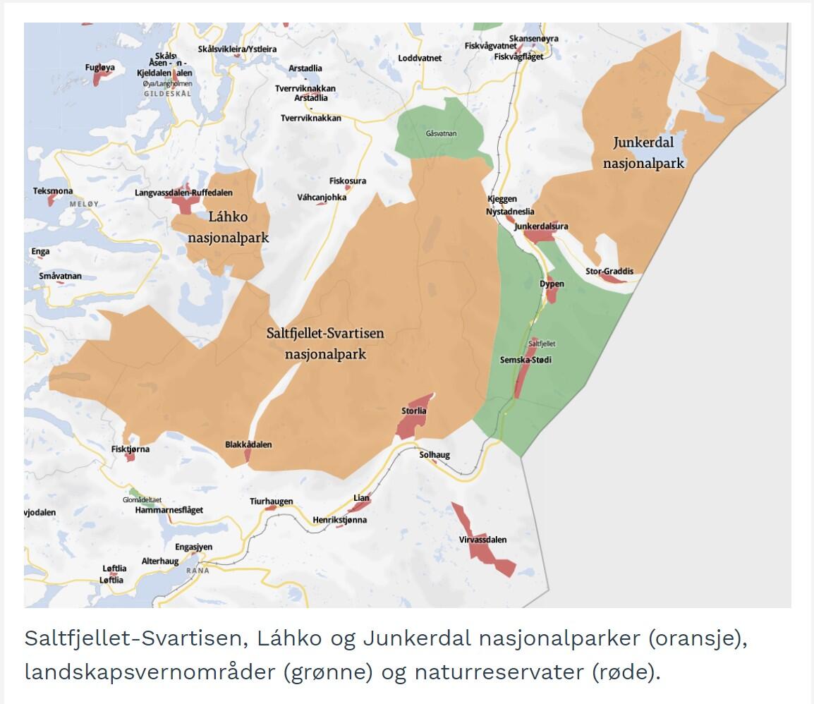
After a half-century struggle between advocates for nature conservation and those for energy development, substantial portions of Saltfjellet were designated as a national park in 1989. Today, this extensive contiguous natural area consists of the national park, three landscape protection areas, and four nature reserves. These protected areas contribute in various ways to preserving the nature of Nordland, from deep fjords and sharp peaks in the west to vast landscapes and wide valleys in the east. This makes Svartisen National Park, along with adjacent protected areas, the most intact and diverse natural area in the entire country. It is also the only area in the country with continuous nature protection from the coast to the Swedish border.

Svartisen National Park is situated in the heart of Nordland county, between Bodø and Mo i Rana. It encompasses a diverse range of unique landscapes, extending from open fjords in the west to vast plains in the east, and dominating the scene is me, the majestic Svartisen glacier, like a blanket draped over the mountainous terrain, serving as a distinct contrast between these two natural extremes. The park is also home to an outstanding assortment of Sami cultural heritage.

Saltfjellet and Svartisen area is considered the oldest and most significant region for Sami cultural heritage south of Finnmark. Numerous traces of Sami settlements, such as stall foundations dating back to the Middle Ages, have been discovered. The tradition of reindeer herding, as seen today, has roots dating back to the 15th and 16th centuries, leaving behind cultural landmarks such as tent sites, shelters, storage chambers, and Sami sacrificial stones and animal graves.


The national park features well-marked hiking trails, including the historic telegraph route between Rana and Saltdal, established in the 1860s to connect northern and southern Norway with a telegraph line. Today, it serves as a 61 km historical walking route with several cabins along the way. The route begins near the E6, close to the historic site of Bredek, following the 1000 pole foundations where the telegraph line ran and passing by the old stone huts used during the 1860s construction. The telegraph route is the trail that allows you to cross Saltfjellet on foot, including the Arctic Circle.

While Engabreen is the main attraction in the west, it's not the only glacier area on Svartisen. On the east side of the glacier, north of Mo i Rana, an old trail leads up to Austerdalsbreen. The easiest access is from Svartisvatnet by boat, and then following the path up to the glacier on the opposite side of the water.


Located on the southern side of the national park, there is a cluster of historical mountain farms that are easily accessible yet definitely worth exploring. Granneset, Inner-Bredek, and Stormdalsgården are unique mountain farms from the 1800s, all within a day's hike from the main road. The area offers a trek through untouched nature, with rushing waterfalls and suspension bridges over swift rivers. Both the "Bredek Round" and the hike to Stormdalsgården are delightful trails that lead you into the national park and past the old mountain farms. The Bredek Round is an 8 km circuit passing by the historic Bredekgården and the impressive Bredekfossen waterfall. Stormdalsgården is further into the valley, following the initial route but with an 8 km detour from the Bredek Round. The hike to Stormdalsgården has been chosen as one of Norway's most beautiful natural gems!

Subject text: Helge Seim

Screenplay: Helge Seim

Voice: Marit Emilie Meidelsen Øvrebø

Editing: Helge seim

Music and Soundeffect: freesound.org


Source:

-Visit Helgeland